I am curious. I am directionally challenged. I am determined.
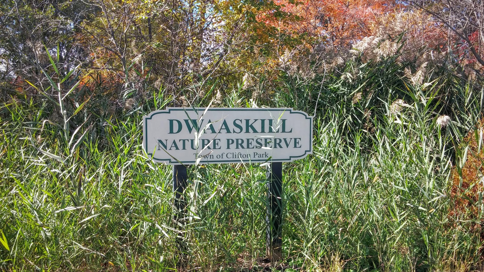
I had some time to kill before work and I just happened to be in Saratoga Springs, NY. I was nervous to do something alone, but I desperately wanted to explore and have myself an adventure. I decided to check out the park around the Roosevelt Baths. After all, I had only ever been there when the ground was covered in snow.
I started at the entrance that had always been closed during previous visits.The trouble was, I didn’t have any cash to pay an entry fee. In fact, I didn't even know how much it would cost if I did have cash...
Luckily for me, there is parking right before the main entry gate.
I got out of my car to look at a park map, but was distracted by a Spring Pavilion right next to NY State Route 50. Of course I went to check it out.
Hathorn No. 3
A sign nearby read, “Saratoga is blessed with naturally carbonated mineral springs that originate in bedrock layers 100 to 1000 feet below the earth’s surface. Carbon dioxide gas in the water forces it to flow out through openings at or near the surface of the earth, creating both free-flowing and spouting springs.
Hathorn No. 3 spring was discovered in 1905. It was protected along with 17 other mineral springs in Geyser Park when New York State passed a bill in 1909 to create a State Reservation here. Today’s Saratoga Spa State Park encompasses the original Reservation land areas of Geyser and Lincoln Parks. Hathorn No. 3, Hathorn No. 2 (now capped), and Coesa were popular trolley car stops on Route 50. Hathorn No. 2 and Hathorn No. 3 had the highest mineral content of the original springs. Hathorn No. 3 mineral spring still remains a free service spring for the public.
An Arts and Crafts style pavilion was constructed over the Hathorn No. 3 spring in 1917, and a Tennessee pink marble fountain was installed the following year. In 2006, the Friends of Saratoga Spa State Park restored the Hathorn No. 3 spring pavilion to its original design.”
While examining the park map near Hathorn No. 3, I saw there was a trail a few yards away. I walked over to see a lovely wooded area and a tree with a trail marker posted "5 mile trail." It was really hot out, and I'm pretty sure I said out loud, "I can't do five miles in this heat." I really wasn't prepared for a long walk. I didn't have water or sunscreen... so I made the final decision to go where I knew I could at least investigate the buildings around the baths.
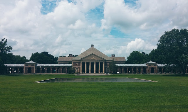
Beginning by the Roosevelt Baths, I walked along the Spa grounds, looking at the architecture and reading inscriptions in the masonry. The expanse of green between the Park buildings added to the greatness of the buildings. A reflective pool was in the center.
I had a sense of calm walking the grounds, as I'm sure it was intended.
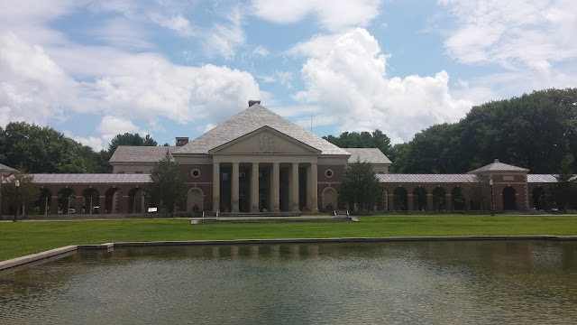 |
| Simon Baruch Research Laboratory, aka Administration Building |
 |
| Hall of Springs |
 |
| Roosevelt Baths & Spa |
The Hall of Springs
A sign by the Hall of Springs read, "Waters from the Geyser, Hathorn, and Coesa Springs were piped into the Hall of Springs for patrons to drink while they strolled or listened to live orchestral music. This building, which included a concert hall, a promenade, writing rooms, lounges, and a restaurant, became the jewel of the entire spa complex."
A sign posted by the Administration Building read, "The arcades allowed patrons to walk in any kind of weather. The 35 inscriptions on the gabled arches of all the arcades are taken from a poem, written between 1817 and 1819 by Rev. Reuben Sears entitled "Mineral Springs of Ballston Spa and Saratoga Spring."
The marble walkway of the arcades have aged over the years, but it is still so lovely to see and walk upon.
I was intrigued by two statues on either side of the main doorway of The Hall of Springs. I looked across the grounds to the Administration Building to see if the buildings were similar, but couldn't tell from my distance with the sun shining so brightly. Eventually, I saw that there were no statues in front of the Administration Building.
A sign near the Hall of Springs read, "The statues located in front of the building were originally part of a representation of the four basic elements: earth, wind, water, and fire. The female figure represents earth, and the male figure represents water. Lack of funding prevented the completion of the statues wind and fire."
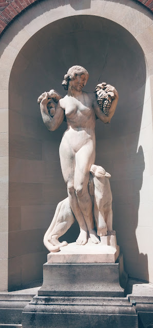 |
| Earth |
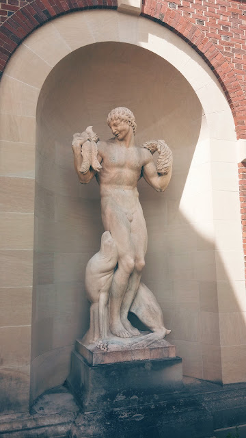 |
| Water |
I continued my exploration. What I was hoping for was to accidentally stumble upon springs I hadn't seen yet. Every map I looked at made it seem like they were easy enough to walk to, but no matter which way I went I never came across any.
I did however walk around a building currently not in use. The top of the main door read, "The Roosevelt Baths."
The currently used Roosevelt Bath & Spa building, directly across from the one not in use, has no access to the back of the building from what I can tell. At least not accessible to the public. I am ever curious, so I looped around to the back of the building.
I kept walking, exploring and some how ended up by the golf course. I checked a park map again... and tried to see if I could get to a spring from where I was. Sadly for me, it didn't seem possible.
I went back to my car. I was planning on calling it a day. I was thirsty and so very hungry. An older couple stopped me to ask why the gates to work the ballet weren't open. I told them, I didn't know anything about a ballet. As I walked away from the couple, I saw a small group of people come out of the woods at the very edge of the parking lot.
A path... "5 mile trail." Nearby was a gravel park road going down a hill. I saw other people biking and hiking on the road, so I went on down the hill.
The Vale of Springs
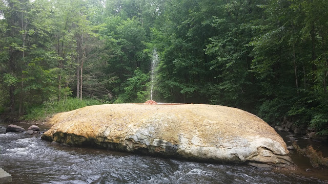
At the bottom of the hill I saw a little bridge. I could barely contain my excitement, or get there fast enough to see the creek that flowed beneath it. I was taken aback when I looked up to see a spouting geyser! This. This? Was at the bottom of the hill where I had parked several times? I was amazed.
The Vale of Springs has a loop trail where you walk along Geyser Creek. I didn't walk the whole loop for several reasons. I was still thirsty, hungry, and the summer heat was taking its toll on my motivation. I had not planned to be out walking for so long. I also needed to be at work fairly soon. But the real reason is, I didn't read how short the loop trail was, because I didn't read the sign about the trail until I was at home.
Orenda Springs. I wanted to see it so bad and I would have certainly taken the time and put in the effort to see it had I known the trail... loop trail at that, was only a half of a mile!
I did however see Polaris Spring, State Seal Spring (which people were gathering drinking water from), Hayes Spring, and Island Spouter Spring.
 |
| Polaris Spring |
 |
| Island Spouter Spring |
Also, farther back in the picnic area there was a different spring, set apart from The Vale of Springs.
Karista Spring
A sign near the spring read, "Karista is the Iroquois word for "iron." This naturally carbonated spring is considered one of the strongest ferruginous, or iron-rich, waters in the world. If you look closely you can see the rusty colored oxidized iron deposits that the water has left behind. Karista ceased flowing in the late 1800's, when carbonic gas companies were pumping massive quantities of spring waters from the area. Yet, out of 163 springs, it was one of 18 left open when private land became a State reservation. Although it was of the last springs to return, Karista had resumed flowing by 1915.
In the 1930's the Spa was looking for mud to use as treatment for arthritis. Geologists studied many areas in search of a rich humus that could only be found in a valley where leaves were allowed to decompose for thousands of years. They found this special, iron-infused mud near Karista Spring. The Spa began offering mud pack therapy to arthritis patients in 1937."
I found my walk to be very interesting and I'm glad I took the time to investigate a curious area in New York State. I am hoping one day I can share my discoveries with my friends and of course make it to Orenda Springs.
Saratoga Springs, NY - July 14th 2015
Distance traveled ~2.9 miles
To see my MyTracks route...
Click Here!
To see all the photos I took...
Click Here!